| MODE-S is a Secondary Surveillance Radar technique that permits selective interrogation of aircraft by means of a unique 24-bit aircraft address, thus avoiding the risk of confusion or mis-identification due to overlapping signals.
Mode S has been standardised by ICAO for many years. It employs ground-based interrogators and airborne transponders and operates in the same radio frequencies (1030/1090 MHz) as conventional SSR systems with which it is backwards compatible.
Mode S has been deployed because the historical SSR systems have reached the limit of their operational capability. This takes the form of exceeded maximum number of targets, RF pollution, lost targets, identity errors and Mode A code shortage. Mode S is therefore a necessary SSR replacement in airspace subject to high levels of traffic density and will form part of the basis of the Surveillance infrastructure for much of the first quarter of the 21st Century.
There are five sources of RF pollution:
- Acquisition Squitter
- Extended Squitter
- ACAStransactions
- Self-generated Second Time Around Replies
- Replies from other Radar Interrogations
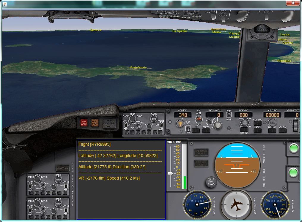
Mode-S employs airborne transponders to provide altitude and identification data, with ADS-B adding global navigation data typically obtained from aGPSreceiver. The position and identification data supplied by Mode S/ADS-Bbroadcasts are available to pilots and air traffic controllers.
Mode S/ADS-B data updates rapidly, is very accurate and provides pilots and air traffic controllers with common air situational awareness for enhanced safety, capacity and efficiency. Further, It can provide a cost-effective solution for surveillance coverage in non-radar airspace.
In Europe, SSR Mode S is being implemented in two stages: Mode S Elementary Surveillance (ELS) and Mode S Enhanced Surveillance (EHS).
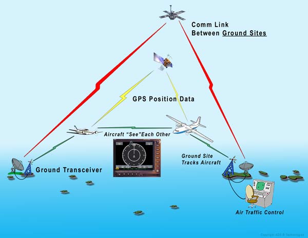
ADS-B is a system in which electronic equipment onboard an aircraft automatically broadcasts the precise location of the aircraft via a digital data link.
The data can be used by other aircraft and air traffic control to show the aircraft’s position and altitude on display screens without the need for radar. The system involves an aircraft with ADS-B determining its position using GPS. A suitable transmitter then broadcasts that position at rapid intervals, along with identity, altitude, velocity and other data. Dedicated ADS-B grounds stations receive the broadcasts and relay the information to air traffic control for precise tracking of the aircraft.
Automatic – Requires no pilot input or external interrogation.
Dependant – Depends on accurate position and velocity data from the aircraft’s navigation system (eg. GPS).
Surveillance – Provides aircraft position, altitude, velocity, and other surveillance data to facilities that require the information.
Broadcast – Information is continually broadcast for monitoring by appropriately equipped ground stations or aircraft.
ADS-B data is broadcast every half-second on a 1090MHz, digital data link.
Broadcasts may include:
-
Flight Identification (flight number callsign or call sign)
-
ICAO 24-bit Aircraft Address (globally unique airframe code)
-
Position (latitude/longitude)
-
Position integrity/accuracy (GPS horizontal protection limit)
-
Barometric and Geometric Altitudes
-
Vertical Rate (rate of climb/descent)
-
Track Angle and Ground Speed (velocity)
-
Emergency indication (when emergency code selected)
Special position identification (when IDENT selected) The ability of a ground station to receive a signal depends on altitude, distance from the site and obstructing terrain. The maximum range of each ground station can exceed 250 nautical miles. In airspace immediately surrounding each ground station, surveillance coverage extends to near the surface.
For further information on Radar techniques and hardware equipments, follow these links:
http://www.radartutorial.eu/index.en.html
http://www.modesbeast.com/
|
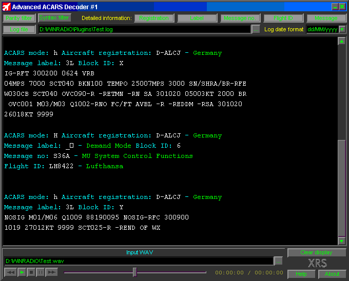
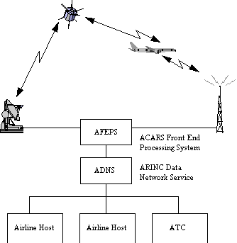
Aircraft Communications Addressing and Reporting System (ACARS) is a digital datalink system for transmission of short, relatively simple messages between aircraft and ground stations via radio or satellite.
The protocol, which was designed by Aeronautical Radio, Incorporated (ARINC) to replace their very high frequency (VHF) voice service and deployed in 1978 uses telex formats. SITA later augmented their worldwide ground data network by adding radio stations to provide ACARS service.
Over the next 20 years, ACARS will be superseded by the Aeronautical Telecommunications Network (ATN) protocol for Air Traffic Control communications and by the Internet Protocol for airline communications.
 Maintenance data download Maintenance data download
The introduction of the interface in the early 1990s between the FDAMS / ACMS systems and the ACARS MU, resulted in datalink's gaining wider acceptance by airlines. The FDAMS / ACMS systems which analyze engine aircraft, and operational performance conditions were now able to provide performance data to the airlines on the ground in real time using the ACARS network. This reduced the need for airline personnel to go to the aircraft to off-load the data from these systems. These systems were capable of identifying abnormal flight conditions and automatically sending real-time messages to an airline. Detailed engine reports could also be transmitted to the ground via ACARS. The airlines used these reports to automate engine trending activities. This capability enabled airlines to monitor their engine performance more accurately and identify and plan repair and maintenance their activities more rapidly.
In addition to the FMS and FDAMS interfaces, the industry started to upgrade the on-board maintenance computers in the 1990s to support the transmission of maintenance-related information in real-time through ACARS. This enabled airline maintenance personnel to receive real-time data associated with maintenance faults on the aircraft. When coupled with the FDAMS data, airline maintenance personnel could now start planning repair and maintenance activities while the aircraft was still in flight.
Interactive crew interface
All of the processing described above is performed automatically by the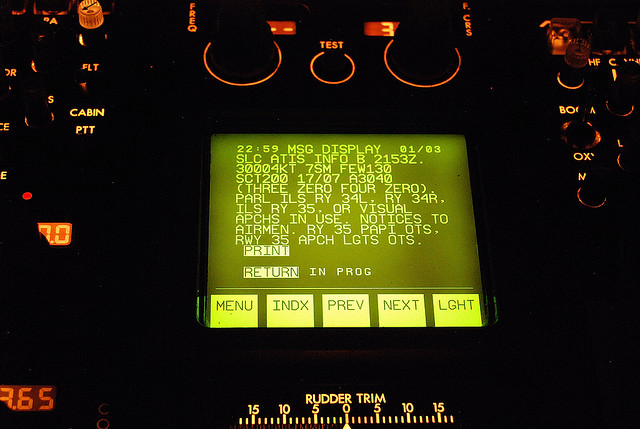 ACARS MU and other associated avionics systems, without flight crew intervention. As part of the growth of ACARS functionality, the ACARS MUs also interfaced directly with a control display unit (CDU), located in the cockpit. This CDU, often referred to as an MCDU or MIDU, provides the flight crew with the ability to send and receive messages similar to today’s email. To facilitate this communication, the airlines in partnership with their ACARS vendor defined MCDU screens that could be presented to the flight crew and enable them to perform specific functions. This feature provides the flight crew flexibility as to the types of information requested from the ground and the types of reports sent to the ground. ACARS MU and other associated avionics systems, without flight crew intervention. As part of the growth of ACARS functionality, the ACARS MUs also interfaced directly with a control display unit (CDU), located in the cockpit. This CDU, often referred to as an MCDU or MIDU, provides the flight crew with the ability to send and receive messages similar to today’s email. To facilitate this communication, the airlines in partnership with their ACARS vendor defined MCDU screens that could be presented to the flight crew and enable them to perform specific functions. This feature provides the flight crew flexibility as to the types of information requested from the ground and the types of reports sent to the ground.
As an example, the flight crew could pull up an MCDU screen that allowed them to send to the ground a request for various types of weather information. After the desired locations and type of weather information were entered, ACARS transmitted this information to the ground. In response to this request message, ground computers sent the requested weather information back to the ACARS MU, which was then displayed and/or printed.
Airlines began adding new messages to support new applications (weather, winds, clearances, connecting flights, etc.) and ACARS systems were customized to support airline-unique applications, and unique ground computer requirements. This resulted in each airline having its own unique ACARS application operating on its aircraft. Some airlines have more than 75 MCDU screens for their flight crews, where other may have only a dozen different screens. In addition, since each airline’s ground computers were different, the contents and formats of the messages sent by an ACARS MU were different for each airline.
|
 Me and two colleagues of mine (Michele Sterlacci and Alessandro de Rosa), have decided to test an ADS-B/MODE-S receiver. The first one, assembled home made, has been installed in the KWOS base where we are using the PlanePlotter software to plot the airplanes' tracks.